
GARDEN ROUTE | KAROO NEWS - A cut-off low-pressure system is expected to develop over the western interior on Wednesday 8 February, moving into the central interior where it will become quasi-stationary from Thursday until Saturday before dissipating on Sunday.
Ample tropically sourced air will be advected southwards from northern Namibia and Botswana, where significant rainfall has occurred lately due to the presence of a tropical low called an ‘Africane’.
Cut-off lows are notorious for causing severe weather in South Africa, such as heavy rainfall and flooding. Due to the slow-moving nature of this cut-off low, persistent rainfall for several days may result in widespread flooding over the central, southern, and eastern parts of the country.
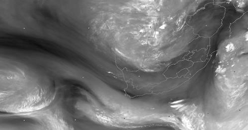 Figure 1: Satellite image at 06h00 UTC on 6 February 2023 indicating the abundance of tropical moisture over Namibia and Botswana with a developing upper-air trough to the west of South Africa. Source: Eumetsat 2023

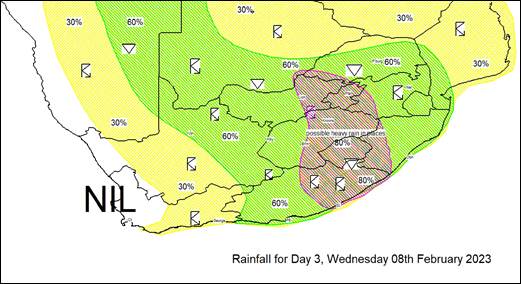 Figure 2: Predicted rainfall probability for South Africa for 8 and 9 February 2023. Source: South African Weather Service
Rainfall is expected to start in the west today, 6 February, and is expected to slowly spread eastwards during tomorrow, with heavier showers and thundershowers possible over the interior of the Eastern Cape during the afternoon and evening.
Once the cut-off low develops on Wednesday evening, rainfall should become widespread, with the possibility of heavy falls in places, over most of the country, excluding the Western Cape and the western parts of the Northern Cape.
Isolated severe thunderstorms may also develop over the central and southern interior due to cooler air aloft associated with the cut-off low.
Due to the extensive cloud cover associated with this system, cooler daytime temperatures can also be expected over much of South Africa.
Given that this system is only expected to develop on Wednesday, there is still a fair amount of uncertainty regarding the rate at which the system will intensify as well as the location and timing of possible severe weather phenomena.
The South African Weather Service will therefore continue to monitor any further developments relating to this weather system and will issue subsequent updates as required. Furthermore, the public is urged and encouraged to regularly follow weather forecasts on television and radio.
Updated information in this regard will regularly be available at www.weathersa.co.za as well as via the SA Weather Service Twitter account @SAWeatherServic
'We bring you the latest Karoo news'