KAROO NEWS - Professor Stefan Grab, a physical geography expert from the University of the Witwatersrand, has uncovered remarkable insights into the historical climate of South Africa's semi-arid central Karoo region that covers up to 400 000km².
The central Karoo region encompasses a wide area, including Colesberg in the north, Aliwal North in the east, Cradock in the south, and Beaufort West in the west. The region is home to some of South Africa's oldest and longest rainfall records.
Speaking at the Graaff-Reinet Museum's annual general meeting in June, he discussed how extreme weather is not a recent phenomenon, but has been part of the region's history (See the 29 June article Scientist here for the weather on the Advertiser's website).
The research paper focuses on the semi-arid region of the central Karoo, famous for its livestock farming and challenging climate. The study's primary goals are to trace historical drought patterns, examine hydroclimatic variations, and compare past droughts with those of neighbouring areas.
To do this, he relied on historical documents (from as early as 1752) and rainfall records (from 1861 to 2022), making use of farm weather books and diaries, newspapers, personal diaries and travel logs, to name a few.
The study's findings are significant and reveals a decline in both the frequency and severity of severe droughts in the Karoo since 1861. The information is invaluable for understanding the long-term patterns of drought occurrence in the Karoo, particularly in an area crucial for livestock farming and currently facing water resource issues. The research also highlights the importance of understanding historical climate conditions in the context of today's changing climate.
Historical rainfall timeline
In an article recently published in the Journal of Arid Environments, Grab explains that drylands cover approximately 41% of the earth's land surface and are characterised by constrained soil development, water scarcity and limited plant cover. Consequently, drylands are considered particularly vulnerable to threats of increased drought under global warming.
The semi-arid Karoo biome in Southern Africa has a complex history shaped by factors like droughts, land use and social changes.
The research paper pieces together a historical rainfall timeline for the Karoo from 1800 to 1880, using historical documentary sources. Some key texts that were used included "Die Noordwaartse Beweging van die Boer voor die Groot Trek" by Van der Merwe, the Grahamstown Journal and Eastern Province Herald. From the extracted information, a relative annual rainfall record was produced using coding descriptions such as "'very dry" (drought year), "relatively dry", "normal", "relatively wet" and "very wet" (flood year). Measured rainfall records starting in 1861 were then used to verify the accuracy of such an approach.
This study marks a significant milestone, offering a comprehensive rainfall chronology for the Karoo region spanning over 200 years. It's the most extended record of its kind for central southern Africa, including both the longest continuous single-station rainfall data spanning 147 years (Wellwood Farm), and the earliest recorded rainfall data from 1861 (Graaff-Reinet). One remarkable aspect of this research is its innovative use of both historical documents and instrumental records to compare 19th-century droughts with those in the 20th and 21st centuries.
Historical droughts in the Karoo
Key findings reveal the variability in the severity of historical droughts in the Karoo, showcasing instances like the drought of 1897, where some areas experienced severe drought while others received near-normal rainfall.
The research also uncovers the complexity of 19th-century droughts in the broader Karoo-Kalahari-Lesotho region, showing that they sometimes affected the entire region, while in other cases, they were limited to specific sub-regions. The study hints at possible influences on these drought patterns, such as the El Niño Southern Oscillation (ENSO) and other climate mechanisms. It also underscores a positive trend: long and severe droughts have become less frequent and the rainfall deficits less intense over the past two centuries in the Karoo. This research not only enriches our understanding of the Karoo's climate history, but also provides important insights into the causes of climatic patterns, which may help manage the future challenges associated with ongoing climate change and variability in this unique dryland region.
If you have any information regarding historic weather events or climate, such as photos of past snowfalls and flooding, please contact him at [email protected] or phone him on 082 828 8673.
He is especially interested in information about snowfall, as this is his current project.
 Stefan Grab
 This rain gauge on the Rubidge's farm Wellwood in the Graaff-Reinet district is still in use. Photo: Stefan Grab
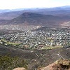
 A Panorama photo of the Nqweba Dam, Graaff-Reinet and Spandaukop. Photo: Sonia Wahl
‘We bring you the latest Garden Route, Hessequa, Karoo news’