
GARDEN ROUTE | KAROO NEWS - The Garden Route starts the new week (and month) on a calm note, with mild temperatures and mostly cloudy conditions expected across the region today, Monday 1 June.
George will reach a comfortable 23°C after an early morning low of 16°C. Clouds will gradually clear during the day, with mist expected later this evening.
Similar conditions are forecast for Riversdale, where temperatures will range between 13°C and 22°C. Morning cloud cover will give way to clear skies before mist develops overnight.
Knysna and Plettenberg Bay can expect pleasant maximum temperatures of 23°C and 25°C respectively. Both towns will enjoy sunny breaks during the day, although cloud cover is expected to increase again later this evening.
No rainfall is forecast anywhere in the region today.
Weather across South Africa
While the Garden Route enjoys mild conditions ahead of the approaching cold front, much of South Africa will experience warm and pleasant weather on Monday.
The warmest conditions are expected along the Eastern Cape coast, with Gqeberha forecast to reach a hot 30°C and East London climbing to 28°C.
In KwaZulu-Natal, Durban is expected to enjoy a pleasant maximum of 25°C, while Pretoria and Johannesburg will remain cooler at 22°C and 20°C respectively.
Bloemfontein starts the day with a chilly 5°C before warming to 23°C, while Kimberley and Upington are expected to reach comfortable highs of 24°C and 27°C.
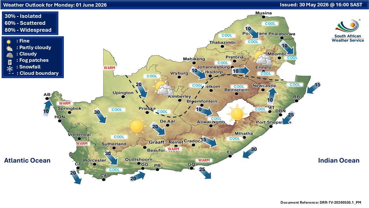
Further north, Polokwane and Mafikeng are forecast to record maximum temperatures of 20°C and 23°C respectively.
The contrast between these generally mild conditions and the severe weather expected later this week in the Western Cape highlights the significant impact the approaching cold front is likely to have on the southern parts of the country.
Conditions remain stable before major change
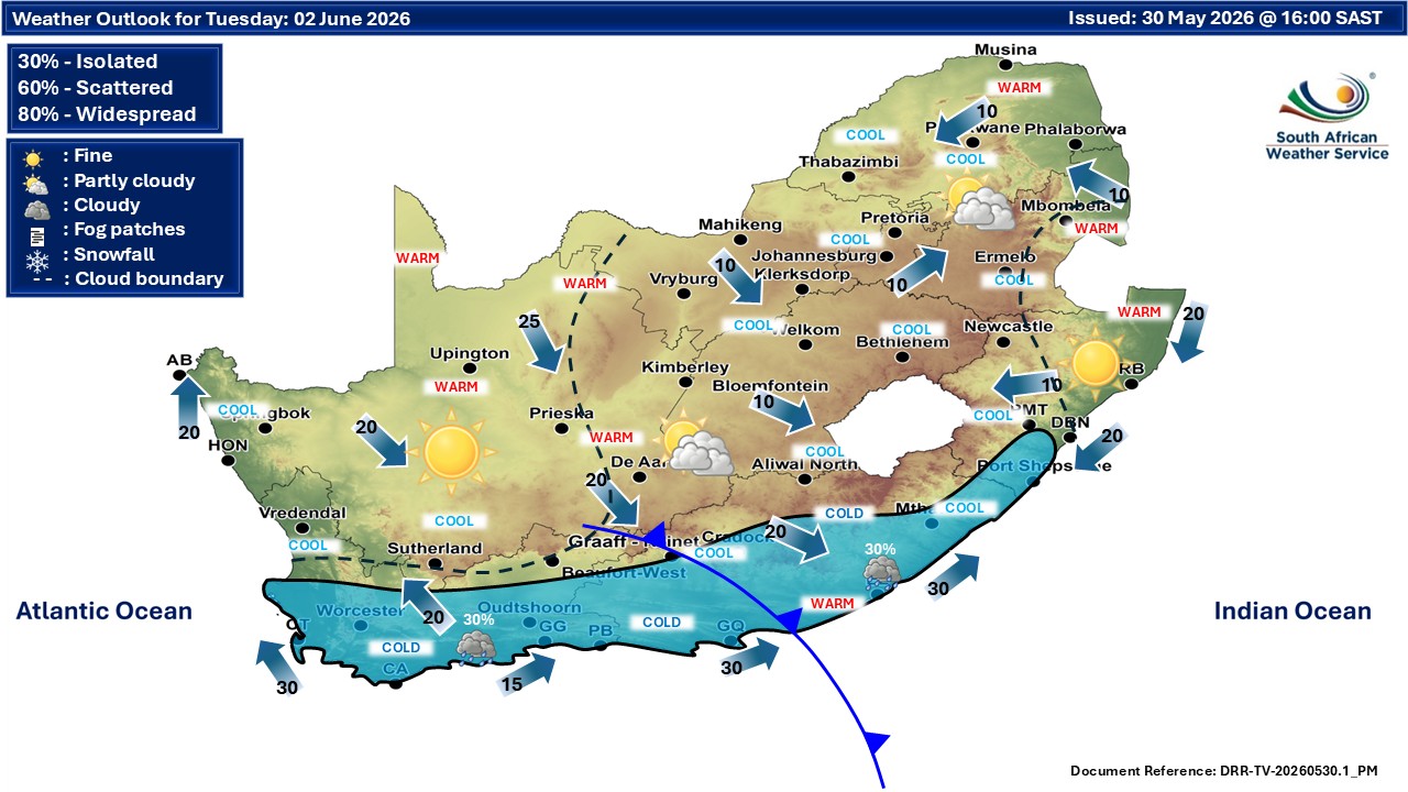
Tuesday is expected to remain relatively settled across much of the Garden Route, with cool winter temperatures and periods of sunshine.
However, weather conditions are expected to deteriorate rapidly from Wednesday as a strong cold front and associated weather system move across the southern Cape.
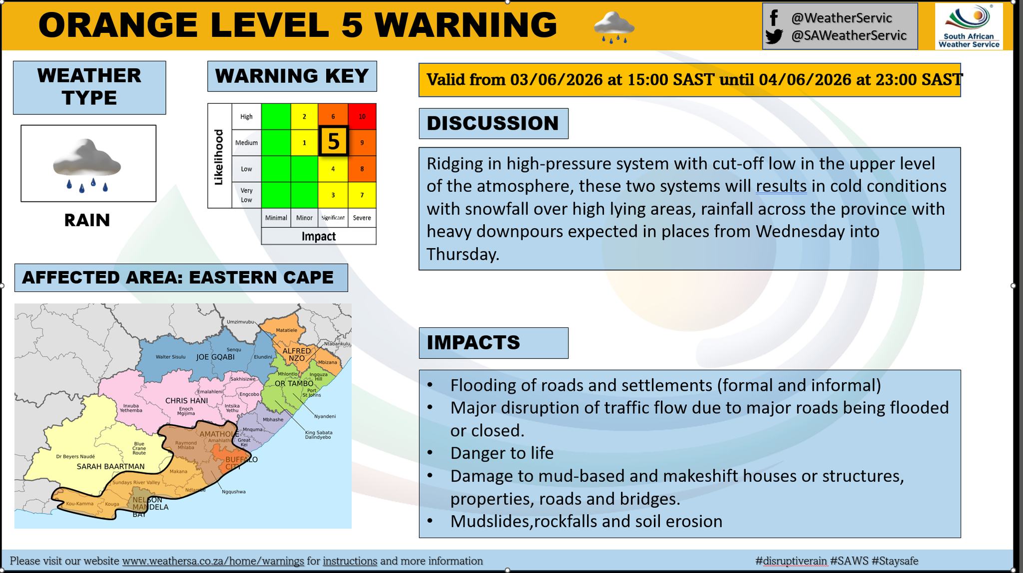
Orange warning issued for flooding
The South African Weather Service has issued an Orange Level 5 warning for disruptive rainfall over the eastern parts of the Garden Route District on Wednesday and Thursday.
Heavy rainfall could result in widespread flooding of roads and bridges, dangerous conditions near fast-flowing rivers and streams, and the possible closure of major transport routes.
Residents in low-lying and flood-prone areas are urged to remain alert and monitor weather updates closely.
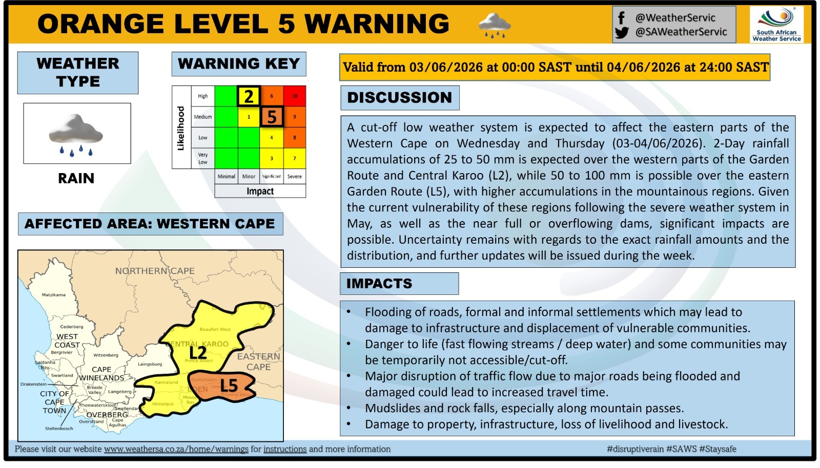
Additional rainfall warning for Western Garden Route
A Yellow Level 2 warning for disruptive rainfall has also been issued for the western parts of the Garden Route and eastern areas of the Central Karoo.
Localised flooding of roads and vulnerable areas is possible during Wednesday and Thursday as rain spreads across the region.
Motorists are advised to exercise caution, particularly on mountain passes and roads prone to water accumulation.
Rough seas and strong coastal winds expected
Maritime conditions are also expected to deteriorate significantly.
A Yellow Level 2 warning for wind and waves has been issued between Cape Point and Plettenberg Bay for Wednesday and Thursday.
Strong winds and rough seas could make navigation difficult and may result in smaller vessels taking on water. Fishermen, recreational boat users and coastal operators are advised to take the necessary precautions.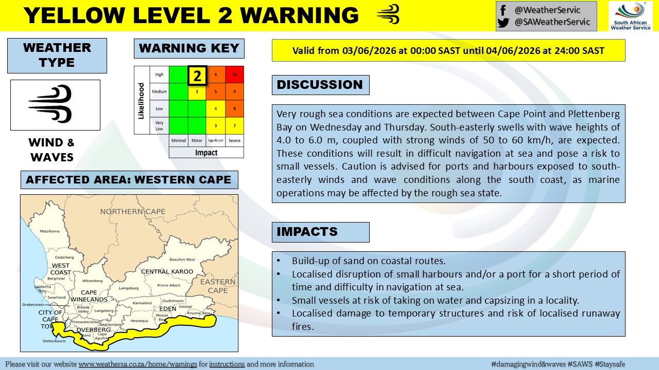
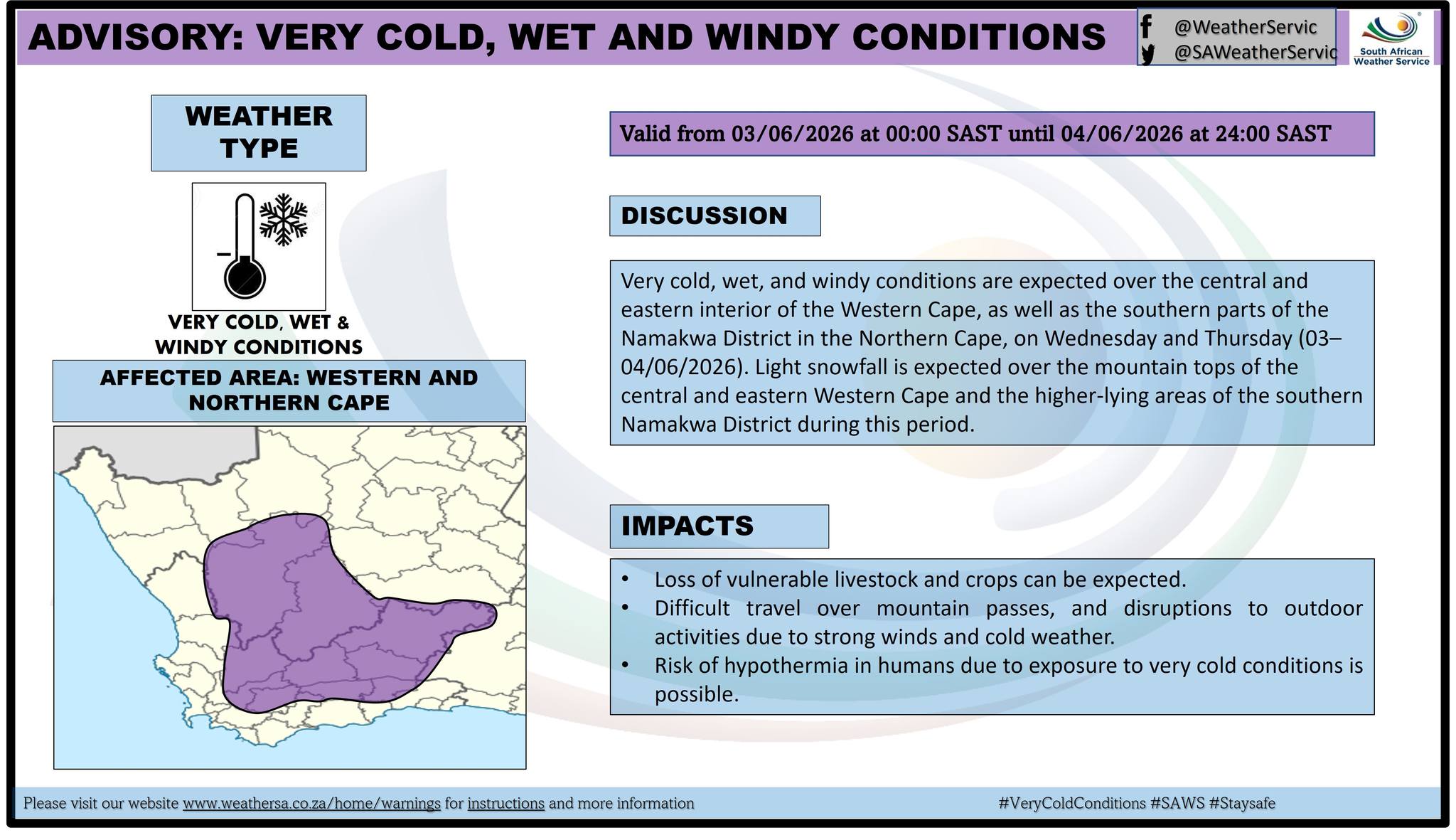
Bitterly cold weather on the way
The cold front is expected to bring very cold, wet and windy conditions across much of the Western Cape's central and eastern interior.
Daytime temperatures are likely to drop sharply from Wednesday, accompanied by strong winds and persistent rainfall.
The South African Weather Service has also indicated that light snowfall is possible over the mountain peaks of the central and eastern Western Cape. Higher-lying areas could experience wintry conditions, particularly during Thursday.
What residents should do
- Avoid unnecessary travel during heavy rainfall on Wednesday and Thursday.
- Do not attempt to cross flooded roads or low-water bridges.
- Secure outdoor furniture and loose objects ahead of strong winds.
- Small craft operators should heed marine warnings.
- Monitor official weather updates for any changes to warnings.
Garden Route outlook for the rest of the week
While Monday and Tuesday offer a brief spell of pleasant winter weather, residents should prepare for a dramatic change from midweek onwards.
The wettest and coldest conditions are expected between Wednesday and Thursday, with flooding posing the greatest threat in the eastern Garden Route, including areas around Knysna and Plettenberg Bay.
Conditions are expected to gradually improve towards the end of the week as the weather system moves eastwards, although cool temperatures are likely to persist.
Residents are encouraged to stay informed through official weather updates and to take precautionary measures ahead of the expected severe weather.
‘We bring you the latest Garden Route, Hessequa, Karoo news’